State of Texas terrain


Print Profile(1)

Description
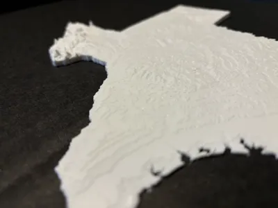
This is the next state in my series, Texas! Updated to use GMTED2010 data and sliced using QGIS to get the state boundaries then exported using DEMto3D plugin to get the STL.
This was modeled and printed with a 0.4 nozzle and I find the terrain details amazing already. Using a 0.2 nozzle may provide additional details but might not be worth the extra time taken to print. Scaling up works fine but I would make sure you have enough bottom layers if trying to scale down. You can probably scale just the z-axis to get more exaggerated terrain, I have not tested this.
This is a big and detailed model, be patient when slicing. Please ensure your bed has proper adhesion, a brim is not recommended as it will be a pain to properly remove due to the tiny curves/angles of the model. Ironing on for the best looking terrain!
Continuing my work on the other US states. I have updated the process such that they will be scaled to fit in with one another like a giant puzzle!
License
You shall not share, sub-license, sell, rent, host, transfer, or distribute in any way the digital or 3D printed versions of this object, nor any other derivative work of this object in its digital or physical format (including - but not limited to - remixes of this object, and hosting on other digital platforms). The objects may not be used without permission in any way whatsoever in which you charge money, or collect fees.
Comment & Rating (47)