Mount Everest 3Dmap 1/100K


Print Profile(1)
Description
The grandeur of mountains and rivers, captured in detail.
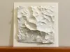
This is the second installment of the Geography Collection: Mount Everest at a scale of 1:100,000.
Let this Geography Collection become one of your 3D printed collectibles, solidifying the unique sky, land, mountains, and water that belong to this Tibetan Plateau.
The model data is sourced from publicly available GIS geographic information systems, covering an area of 20 kilometers * 20 kilometers.
With a unique dual-color treatment, the model can express a subtle gradient from gray to white.
Print plate 2 is a 250mm * 250mm backing plate with a name tag. The main body and backing plate are bonded, and can be combined with a 250mm square frame to create a unique home decor item.
Hope you, a geography enthusiast, will love this model!
Boost Me (for free)
Mount Everest, captured in detail!
License
You shall not share, sub-license, sell, rent, host, transfer, or distribute in any way the digital or 3D printed versions of this object, nor any other derivative work of this object in its digital or physical format (including - but not limited to - remixes of this object, and hosting on other digital platforms). The objects may not be used without permission in any way whatsoever in which you charge money, or collect fees.
Comment & Rating (3)